Monday, April 8, 2013

Sand Ridge State Forest

April 6-7, 2013
Last weekend, my wife wanted to have a dinner party.  Those plans fell through on Thursday, so, since I haven’t been on a hike for 2 months, I decided to take an overnighter at one of the parks.  I looked at Sanganois, but it does not have camping.   So I decided to try Sand Ridge and saw that it has backcountry camping.  That fit the bill so on Saturday morning I packed up and headed south.


I arrived at the park at 12:30, to a beautiful 70 degree, windy day!  I checked in at the forest headquarters and got a permit.  It is only $6.00 a night.  The manager helped me pick a spot and then I drove over to the trailhead and got underway about 1:00 p.m.  First thing I saw were several prickly pear cacti!  I was quite surprised that cacti could survive the winter in Illinois, but there they were lining the sand trail.  When I say “sand” I don’t mean packed down sand like a baseball diamond.  I mean loose sand like a beach.  Hiking in that loose sand is quite difficult and really slows one down.  I stayed on the edge of the trail as much as I could, but even there it was loose and my feet sank in quite a bit.  Even so, I was able to keep my average speed over 2 mph.

The park sits on a large area of sand which was deposited by glaciers about 15,000 years ago.  Just after the glaciers melted a long dry period created a desert in the area.  That is when the various cactus and other desert plants became established in the area.  There is a large oak forest (about 4000 acres) and also a pine forest (about 2500 acres) which was planted by the CCC in the 1930s.  The pine forest has large areas of straight rows just as one would expect in a tree farm.  I hiked in the pine forest because the oaks were not in leaf this early in the season.

The SF has a hand trap and archery range.  There are also 120 miles of equestrian trail and equestrian day use and camping areas.


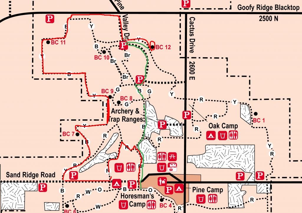
Sand Ridge SP Hike photo sandridgemapmarkupcrop.jpg
Red is Inbound hike; Green is Outbound

I decided to start on the Red Trail and then hike around the northwest portion of the park (Blue/Yellow Trail) and then come around east on the northern trail to BC12 campsite.  That site is located at the mid-point of the north part of the Yellow trail (the northernmost trail in the park).  It was tough, especially climbing the sand dunes that the trail traverses.

I hiked 6.5 miles into the camp site and arrived at 4:00 on the dot.  It is a very nice camp site and has at least ten hammock hanging positions among the pines.  I got a nice fire going as the wind, which had gusted and blown hard all afternoon died down with the coming of dusk.  I broke out the IMUSA 10cm cook kit and had a nice hot dinner.  This was only the second time I have had a chance to use it in the field and it performed excellently. 

After sitting by the fire for a couple hours I called it a day and hit the sack.  I was too warm at first and so I took off my tee shirt and put the top quilt down.  Eventually, thunderstorms rolled in and the temps dropped.  I could hear the thunder for at least 30 minutes before the storm hit.  It was really neat to listen as it rolled in.  After the second storm blasted through I slept pretty soundly until about 6:30 a.m.

I finally got up at 7 and slowly packed up the gear.  I hit the trail at 8 and hiked 2.25 miles south to the car.  While walking a Ring-necked Pheasant crossed the trail just about 20 feet in front of me.  I tried to get a photo, but it got into the trees before I could get the camera turned on.  During the night and early morning hours I heard Great Horned owls, wild turkeys gobbling, cardinals, blue-jays, various other songbirds, and coyotes.  I got to the car at 9:00 am and drove home.  My legs and the arches of my feet were already getting stiff form walking in the sand, but overall, I felt pretty good.  I am encouraged that I will be able to increase my mileage this summer.

2 comments:

  1. I was curious, is the trail well marked? I was planning on using this trail for my first backpacking experience. Well the first in a few years. I had a back injury awhile back and im finally trying to get back into backpacking.

    ReplyDelete
    Replies
    1. Yes, the trail is well marked. In my vid at 15:22 I have a photo showing the colored squares with my trekking poles leaning up against. The trails are color coded, blue, green, brown, etc. Note on the map above the trails have a B, or a G or Br on them. Those are colors. And the map of the park is available on the IDNR website. The campsites are well marked also.
      Enjoy!

      Delete